


09 NOBLE, Noble County, Indiana
About
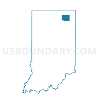
Outline

Summary
| Unique Area Identifier | 579931 |
| Name | 09 NOBLE |
| County | Noble County |
| State | Indiana |
| Area (square miles) | 22.30 |
| Land Area (square miles) | 21.42 |
| Water Area (square miles) | 0.88 |
| % of Land Area | 96.06 |
| % of Water Area | 3.94 |
| Latitude of the Internal Point | 41.32350000 |
| Longtitude of the Internal Point | -85.47876160 |
Maps


Graphs
Select a template below for downloading or customizing gragh for 09 NOBLE, Noble County, Indiana


Neighbors
Neighoring Voting District (by Name) Neighboring Voting District on the Map
- 01 WASHINGTON, Noble County, IN
- 08 YORK, Noble County, IN
- 10 GREEN, Noble County, IN
- 11 JEFFERSON, Noble County, IN
- 29 NOBLE, Noble County, IN
Top 10 Neighboring County Subdivision (by Population) Neighboring County Subdivision on the Map
- Noble township, Noble County, IN (3,094)
- Green township, Noble County, IN (2,123)
- York township, Noble County, IN (1,605)
- Jefferson township, Noble County, IN (1,604)
- Washington township, Noble County, IN (1,200)
Top 10 Neighboring Unified School District (by Population) Neighboring Unified School District on the Map
- West Noble School Corporation, IN (12,950)
- Central Noble Community School Corporation, IN (8,759)
- Smith-Green Community Schools, IN (7,423)